Epsilon Geomatics
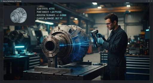
We bridge the gap between heavy manufacturing and digital intelligence using surgical LiDAR and 3D laser scanning.
Scanning Active
Processing Point Cloud: 4.2M Points/Sec
TECHNICAL WORKFLOW
High-density laser capture of geometry, textures, and internal features with zero physical contact.
Billions of data points are aligned and filtered into a watertight polygonal mesh (STL/OBJ).
Manual extraction of design intent to create editable, feature-based solids with history tree.
Final delivery in native formats (SolidWorks, Inventor, AutoCAD) with full assembly hierarchy.
Our commitment to ±0.01mm precision isn’t just a claim—it’s a verifiable standard. We employ rigorous verification steps for every industrial scan.
All hardware is calibrated against NIST-traceable artifacts before every major project deployment.
We provide color-coded heat maps comparing the final CAD model against the raw point cloud to prove fidelity.
Critical dimensions are cross-verified using manual precision calipers and depth gauges for secondary redundancy.
PRECISION REPORT SAMPLE
ISO 9001:2015 COMPLIANT
Digitizing complex airfoil surfaces for aero-dynamic analysis and manufacturing of critical legacy blades.
Preserving “as-built” data for legacy pipelines and historical steel structures where drawings are lost.
3D mapping of entire plant floors for clash detection and equipment relocation optimization.
We don’t just deliver data; we deliver productivity. Our outputs are natively compatible with the industry’s leading design and engineering software.
AutoCAD Native
Civil 3D
Autodesk Revit
SolidWorks
AUTODESK
SOLIDWORKS
BENTLEY
SCANNING TOLERANCE
CLOUD DENSITY
CAPTURE SPEED
DELIVERY TIME